Article 4 of Resolution 139/2024/QH15, dated 28 June 2024, by the 15th National Assembly on the National Marine Spatial Planning for the 2021 - 2030 period, with a vision to 2050, stipulates that the zoning of marine spatial use in national sea areas shall be carried out in accordance with the principle of resolving overlaps in the following order of priority.
1. Requirements for ensuring national defence and security; 2. Requirements for the protection and conservation of marine ecosystems; 3. Requirements for economic development activities. In cases of overlap among activities for economic development purposes, priority for marine spatial use shall be given in the following order: (a) marine tourism and services; (b) maritime economy; (c) exploitation of oil and gas and other marine mineral resources; (d) aquaculture and fisheries; (e) renewable energy and emerging marine economic sectors.
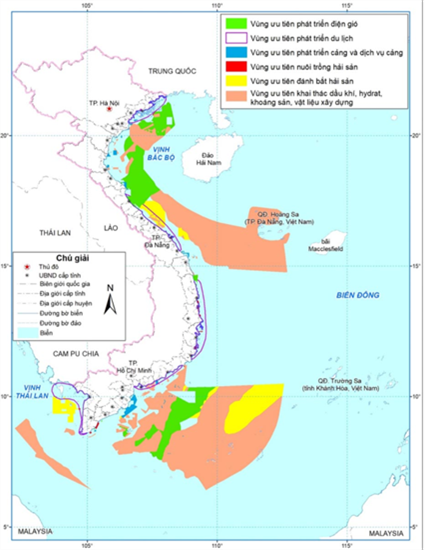 |
| Map of national marine spatial use zoning (photo: tapchikientruc.com.vn) |
Where necessary, following proposals from provincial-level people’s committees and relevant ministries and sectors, the Ministry of Agriculture and Environment shall submit adjustments to the order of priority for marine spatial use in specific maritime zones to the Prime Minister, based on analysis and assessment of economic, social, and environmental effectiveness and benefits as well as the capacity to facilitate the protection of national sovereignty and security at sea.
1. Northern sea area
- Prohibited exploitation zones: a total area of approximately 12,000 hectares, comprising 18 prohibited exploitation zones for marine conservation purposes and 8 reserve zones.
- Conditional exploitation zones: a total area of approximately 478,000 hectares, comprising 31 conditional exploitation zones for conservation and protection purposes and 68 other conditional exploitation zones.
- Areas requiring special protection: a total area of approximately 43,000 hectares, comprising 155 areas.
- Development promotion areas:
+ Priority development promotion areas: a total area of about 167,000 hectares, comprising 4 areas prioritised for tourism development and 11 areas prioritised for port service development.
+ Areas with exploitation and development potential: a total area of approximately 2,245,000 hectares, including areas with potential for oil and gas extraction, areas with potential for construction material exploitation, areas with potential for placer mineral extraction, and areas with potential for wind power development.
+ Multi-purpose use area: approximately 380,000 hectares.
2. Central sea area
- Prohibited exploitation zones: a total area of approximately 45,000 hectares, comprising 38 prohibited exploitation zones for marine conservation purposes and 20 reserve zones.
- Conditional exploitation zones: a total area of about 20,441,000 hectares, comprising 73 conditional exploitation zones for conservation and protection purposes and 96 other conditional exploitation zones.
- Areas requiring special protection: a total area of approximately 22,000 hectares, comprising 62 areas.
- Development promotion areas:
+ Priority development promotion areas: a total area of approximately 267,000 hectares, comprising 19 areas prioritised for tourism development and 28 areas prioritised for port service development.
+ Areas with exploitation and development potential: a total area of approximately 18,671,000 hectares, comprising areas with potential for oil and gas exploitation, areas with potential for methane hydrate exploitation, areas with potential for construction material exploitation, areas with potential for placer mineral exploitation, areas with potential for deep-sea metallic mineral exploitation, and areas with potential for wind power development.
+ Multi-purpose use area: approximately 23,897,000 hectares.
(To be continued)
PHAM BINH