 |
|
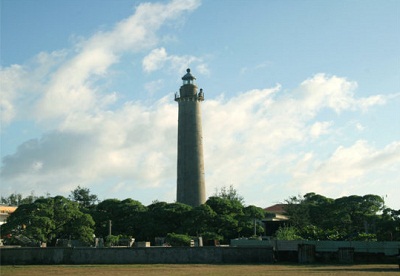
A lighthouse on Southwest Cay (Song Tử Tây) island |
Vietnam is a littoral country, locating to the west of the East Sea. It has a long coastline of over 3,260 km long, over 3,000 islands of different sizes and the two Spratly and Paracel archipelagos. According to the United Nations Convention on the Law of the Sea (UNCLOS) 1982, Vietnam’s waters include: internal water, territorial sea, contiguous zone, exclusive economic zone and a continental shelf of 200km wide from baseline. Geographically, Vietnam’s seas and islands cover a wide range of area which can be sorted into main regions as: the Gulf of Tonkin, the Gulf of Thailand, Paracel and Spratly archipelagos, and some other islands and archipelagos.
The Gulf of Tonkin locates to the northwest of the East Sea. The Gulf is defined in the west by the northern coastline of Vietnam, in the north by China's Guangxi province, and to the east by China's Leizhou Peninsula and Hainan Island. Its area is around 126,250 km2 with widest part of about 310km and narrowest part of about 240km, connecting to the East Sea through the southern estuary of about 240 km wide and the eastern estuary of about 18km wide. In 2000, Vietnam and China signed the Agreement on Maritime Boundary Delimitation in the Gulf of Tonkin, followed the equitable principle of division with median line from the north to the south as the demarcation line. Accordingly, there are thousands of islands of different sizes in Vietnam’s ownership of the gulf, including Bach Long Vi island (with about 2,5 km2 in area) which is 110km from Vietnam and 130 km from China’s Hainan island.
2. The Gulf of Thailand locates to the southwest of the East Sea with an area of about 293,000 km2 and a perimeter of about 2,300 km and is surrounded by the coasts of Vietnam, Cambodia, Thailand and Malaysia. This water is rather shallow with its deepest point of just about 80m. Vietnam’s water in the gulf includes a number of islands, the biggest of which is Phu Quoc with an area of around 567 km2.
3. Vietnam’s islands and archipelagos disperse widely. There are over 3,000 islands in the coastal waters, mainly in the Gulf of Tonkin. The remainders are in the north central region, middle central region and the southwest region. Besides, there are some offshore islands. The two Paracel and Spratly archipelagos locate in the middle of the East Sea. On the basis of the geographical condition, the strategic importance in economic, defence and security and on the population, the country’s islands and archipelagos can be sorted into: the group of outpost and big islands with favourable natural conditions for developing sea economy and group of coastal islands with favourable conditions for developing aqua fishery, tourism and serve as bases for maintaining safety and order in the coastal regions. The group of outpost islands consists of offshore islands and archipelagos, such as Paracels, Spratlys, Chang Tay, Tho Chu, Phu Quoc, Con Dao, Phu Quy, and Bach Long Vi, etc. These are important outposts in the cause of national development and defence.
Vietnam’s seas and islands are an indispensable part of the country’s territory. They have been the living and developing space of our nation for thousands of years. Each island is not only the dweller of Vietnamese people but also a natural landmark indicating sacred sovereignty of the country. For this reason, protecting and developing sea and island potentialities have always been the cause of the whole party, every sector, level; localities, the armed forces and the whole nation.
Hai Bang