Statement of the Government of the Socialist Republic of Viet Nam on the baselines for measuring the breadth of the territorial sea in the Gulf of Bac Bo
Pursuant to the Resolution No. 68/NQ-UBTVQH15 dated 14 February 2025 of the Standing Committee of the 15th National Assembly of the Socialist Republic of Viet Nam, on 21 February 2025, the Government of the Socialist Republic of Viet Nam issued the Statement on the Baselines for Measuring the Breadth of the Territorial Sea of the Socialist Republic of Viet Nam in the Gulf of Bac Bo. This statement is in accordance with the United Nation Convention on the law of the sea 1982 (UNCLOS) and Vietnam Sea Law 2012.
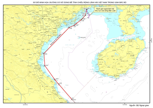 |
| Illustration of the baseline for measuring the breadth of the territorial sea of Vietnam in the Gulf of Bac Bo (Photo: nhandan.vn) |
Accordingly, the baseline for measuring the breadth of the territorial sea of the mainland territory of Viet Nam in the Gulf of Bac Bo consists of the straight lines joining the basepoints as listed below:
|
Points
|
Name
|
Coordinate (WGS-84)
|
|
Latitude (N)
|
Longitude (E)
|
|
A11
|
Con Co Island, pursuant to the
Statement of 12 November 1982 by the Government of the Socialist on the Territorial Sea Baseline
of Viet Nam
|
17o10’00.0”
|
107o20’36.0”
|
|
A12
|
Gio Lon Islet
|
17o054’48.1”
|
106o40’25.8”
|
|
A13
|
Chim Islet
|
18o07’02.5”
|
106o29’23.7”
|
|
A14
|
Mat Con Islet
|
18o47’28.2”
|
105o59’20.5”
|
|
A15
|
Hon Me Island
|
19o22’36.7”
|
105o56’18.6”
|
|
A16
|
Long Châu Dong Island
|
20o36’47.9”
|
107o12’32.2”
|
|
A17
|
Ha Mai Island
|
20o42’58.6”
|
107o27’14.9”
|
|
A18
|
Ha Mai Island
|
20o43’21.3”
|
107o27’50.2”
|
|
A19
|
Thanh Lam Island
|
20o59’02.3”
|
107o49’20.9”
|
|
A20
|
Thanh Lam Island
|
21o01’25.9”
|
107o51’46.5”
|
|
A21
|
Bo Cat Islet
|
21o11’19.6”
|
108o01’09.6”
|
|
A22
|
Bo Cat Islet
|
21o11’29.2”
|
108o01’17.7”
|
|
A23
|
Tra Co Island
|
21o28’14.9”
|
108o05’32.8”
|
|
A24
|
Marking Point No. 1 under the
Agreement between the Socialist Republic of Viet Nam and the
People’s Republic of China on the Delimitation of the Territorial Seas, Exclusive Economic Zones and
Continental Shelves in
the Gulf of Bac Bo
|
21o28’12.5”
|
108o06’04.3”
|
The baseline for measuring the breadth of the territorial sea of Bach Long Vi Island is the low-water line along the coast of the island.
The outer limit of the territorial sea of the Socialist Republic of Viet Nam in the area adjacent to the mouth of the Bac Luan River is determined by nine points along the territorial sea delimitation line between the Socialist Republic of Viet Nam and the People’s Republic of China in the Gulf of Bac Bo and point 10 located within the waters of Viet Nam. The coordinates of the points are listed below:
|
Points
|
Coordinates
|
|
Latitude (N)
|
Longitude (E)
|
|
1
|
21o28’12.5”
|
108o06’04.3”
|
|
2
|
21o28’01.7”
|
108o06’01.6”
|
|
3
|
21o27’50.1”
|
108o05’57.7”
|
|
4
|
21o27’39.5”
|
108o05’51.5”
|
|
5
|
21o27’28.2”
|
108o05’39.9”
|
|
6
|
21o27’23.1”
|
108o05’38.8”
|
|
7
|
21o27’08.2”
|
108o05’43.7”
|
|
8
|
21o16’32.0”
|
108o08’05.0”
|
|
9
|
21o12’35.0”
|
108o12’31.0”
|
|
10
|
21o03’33.1”
|
108o10’57.7”
|
The baseline used to measure the breadth of Vietnam's territorial waters in the Gulf of Bac Bo is determined on the basis of the provisions of UNCLOS, in accordance with the geographical and natural features of the Gulf of Bac Bo and does not affect international treaties to which Vietnam has signed or acceded; is the basis for determining the boundaries and scope of Vietnam's maritime zones according to the provisions of UNCLOS and the Agreement on the Delimitation of the Gulf of Bac Bo signed by Vietnam and China in 2000, creating additional legal basis to protect and exercise Vietnam's sovereignty, sovereign rights, and jurisdiction, serving marine economic development and management, and promoting international cooperation.
PHAM BINH