Spratly and Paracel Islands in Vietnamese and international ancient books and maps
Located in the East Sea, between 15045’-17015’ N and 1110-1130 E, Paracel Islands, are a group of more than 30 islands and various coral islets, reefs and shoals. The distance is approximately 120 nautical miles from Ly Son Island (Quang Ngai Province). Spratly Islands, located between 6050’-120 N and 111030’-117020’ E, are a group of more than 100 islands, a lot of reefs and cays, approximately 203 nautical miles from Phu Quy Island (Binh Thuan Province). The two offshore archipelagos are an integral part of Vietnam’s territory.
 |
|
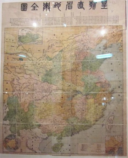
"The Map of All Chinese Provinces" published in 1904 does not include Paracel and Spratly Archipelagos |
Over the past centuries, Vietnam has continuously claimed and peacefully exercised its sovereignty over the two archipelagos (before that, they were terra nullius). The evidences were recorded long time ago in Vietnam’s ancient maps such as: Toan Tap Thien Nam Tư Chi Lo Do Thu (the Route Map from the Capital to the Four Directions 1686), Giap Ngo Binh Nam Do ( ‘a Map of Southern Vietnam’ 1774), An Nam Dai Quoc Hoa Do (Map of the Empire of Annam) and Dai Nam Thong Nhat Toan Do (Map of United Dai Nam). Toan Tap Thien Nam Tu Chi Lo Do Thu (the Route Map from the Capital to the Four Directions), a Vietnamese atlas compiled and drawn by Do Ba, depicted Paracel and Spratly Islands as parts of Quang Ngai district, Quang Nam province as follows: “The long sandbank called Golden Sandbank, around 400 miles long and 20 miles wide, emerges in the sea, facing the coastline between the harbor of Dai Chiem and that of Sa Vinh …”. Dai Nam Nhat Thong Toan Do (The Complete Map of the Unified Dai Nam-1838) known as Vietnam’s atlas during Nguyen’s Dynasties published in 1838 specifies that: the Paracels and Ten Thousand Mile Long Sand (or the Spratlys) belong to Vietnam’s territory. Notably, in An Nam Dai Quoc Hoa Do (Map of the Empire of Annam 1838), Bishop J.L. Taberd drew part of Paracel Islands and noted that “Paracel-Golden Sandbank” is further offshore compared to coastal islands of Central Vietnam.
Together with above-mentioned ancient maps, many of Vietnam’s ancient geographic books recorded the two archipelagos, such as: Phu Bien Tap Luc (Miscellany on the Government of the Marches 1776), Lich Trieu Hien Chuong Loai Chi (Regulations of Successive Dynasties by Subject-Matter, 1821), Hoang Viet Dia Du Chi (Geographical Treatise of Imperial Vietnam, 1833), Dai Nam Nhat Thong Chi (Geography of the Unified Dai Nam 1882), etc. Phu Bien Tap Luc (Miscellany on the Government of the Marches ), a book of geography and history by scholar Le Quy Don, clearly indicated that Dai Truong Sa (including the Paracels and the Spratly Islands) belong to Quang Ngai Prefecture . The book said that: “An Vinh Commune, Binh Son District, Quảng Ngãi Prefecture has a mountain outside its seaport. This 30 miles wide mountain is called Re Island. It takes four watches to reach the island, on which there is a ward named Tu Chinh with beans-growing inhabitants. Further offshore are the Dai Truong Sa Islands…”. And Dai Nam Nhat Thong Chi (Geography of the Unified Dai Nam) said that: “In the east of Re Island, Binh Son District is Hoang Sa Islands. It might take by boat 3 or 4 days and nights to get there from Sa Ky seashore in good weather conditions. There are more than 130 small islands which take a day or several watches to travel across. The long stretching golden sandbank in Hoang Sa Islands called the Ten Thousand Mile Long Sand (Van Ly Truong Sa) on which there are drinkable wells, and numerous kinds of birds. There were a large number of sea cucumbers, tortoise-shells, sea snails, chelonians, and so on. There were also pieces of ship-wrecked cargoes drifted to the sand”.
Besides Vietnam’s ancient maps and books, a lot of Western navigators and clergymen’s documents written in the past centuries specified that the Paracel and Spratly Islands belong to Vietnam. A Western clergyman wrote in a letter during his trip on Amphitrite Ship from France to China in 1701 that: “Paracels is an archipelago of the Kingdom of Annam”. French Bishop, J.T. Taberd wrote in his note “Geography of Cochinchina” published in 1837 that: “Pracel or Paracels is part of Cochinchina’s territory” and that Cochinchinese people called Pracel or Paracels “Golden Sand”. The book “Geography of Cochinchinese Empire”, published in 1849 by Gutzlaff, clearly stated that Paracels belong to Vietnam and noted Paracels in Vietnamese as “Cát Vàng” (Golden Sand).
All of the aforementioned documents clearly demonstrate Vietnam’s long-lasting and continuous sovereignty over Paracel and Spratly Islands which over the past centuries have been integral parts of Vietnam’s territory.
Ta Quang